473
Smart Gaging GPS Flow Meter
Flow Meter
  • Reliable DGPS differential technology and wireless network technology, allowing for sub-meter level tracking accuracy and accurate flow velocity and direction with no artificial and objective error accumulation.

  • Simultaneous measurement, storage and sendingreal-time communication, ensuring thesafe and completedata can be stored completely and traceablystorage.

  • Strong environmental adaptability, not affected by low-visibility, rain and snowheavy weather, navigation restrictionsrestrictedvoyage, etc.

  • Safe, easy and flexible to deploy and operate, no need forwithout any restrictions of carrier platforms such as trimaran, unmanned surface vehicle, unmanned aircraft, survey boat, etc. The float is not needed innecessary to keep in sight, improving the workermanpower safety.

  • The powerful software can monitor and collect various data in real time, reducing thelabor force and improving workefficiency.

  • High cCost-effective integratedsystem, with lower costcompared with other traditional hydrological measurement equipmentsystem ranging from tens of thousands to hundreds of thousands.

  • Easy maintenance, only float replacement is requiredno need for extra maintenance except for charging the float.


Contact Us:

Overseas Sales Manager:

Ms. Jing Chai
+86 15895347296
jing.chai@haiyingmarine.com
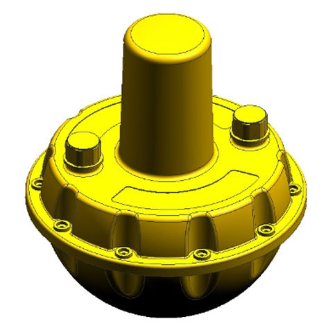
The Smart Gaging is a GPSanintelligent flow meter that worksmeasureswith the Doppler value obtained fromCarrier phase Differential GPSthe carrier phase difference. The system consists of a high-strength floating ball, a built-in high-precision GPS module and an integrated software system. It can accurately measure the surface velocity and flow direction by drifting with the flowin water.

The software uses a built-in 4G (upgradeable to 5G) real-time communication module to collect and display data such as the trajectory, time, position, velocity and flow direction of the floating ball. These data can be stored onuploaded to the server in real time, andcan be exported as theto majorformat required by the hydrological industry, so you don't have to worry about data losswithout any concern of datasafety. After themeasurement, the track line can be replayedon map to help retrieve the floating ball.

System

Processor

48MHz   Cortex-M0, 32-bit CPU

ROM

64K   Flash

RAM

8K

GPS

Fastest   reported frequencyUpdate rate

Min.100ms

Velocity   accuracy

0.05m/s

Direction   accuracy

0.03°

Position   accuracy

<1m(GPS)

Position   system

GPS,   GLONASS, BeiDou

Gain   of antenna

3.5dBi

Communication

Frequency   band

FDD:B1/B3/B5/B8

TDD:B38/B39/B40/B41

WCDMA:B1/B8

TD-SCDMA:B34/B39

CDMA:BC0

GSM:900/1800MHz

Networks   operator

Mobile/Unicom/Telecom

SIM

Micro   Sim

Function

Uploaded   data

Longitude,   latitude, velocity, altitude, time, direction,

 estimation accuracy

Storage

1000   data

Upload   feature

Data   can be stored in flash memory temporally when signal is interrupted, and   continue to be uploaded when signal resumes.

Upload   frequencyrate

Remote   configurable

External   interface

Charging   interface

5pin   Micro USB

On-off

Push-Push

Power   supply

Operating   voltage

3.6V~4.3V

Battery

5000mAH

Charging   voltage

5V/1A   DC

Working   time

48 hours(upload   per second)

Indicator

Power/GPS/4G   communication

Environment

Temperature

-40℃   ~ 80℃

Humidity

10%   ~ 90%


Name Type Size Download
Copyright © 2017 Wuxi Haiying-Cal Tec Marine Technology Co., Ltd. 苏ICP备11057218